

Temperatures Rise Again with Red Heat Warning in Effect
Temperatures are increasing rapidly once more on Friday across parts of the UK following another record-breaking day on Thursday.
Many areas in southern England and Wales experienced overnight temperatures that remained above 20°C.
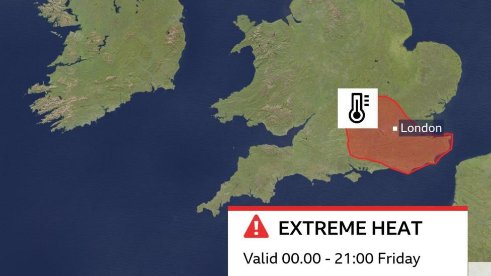
A Met Office red warning for extreme heat is active for parts of south-east and central southern England, extending up to Oxfordshire until 9pm. Temperatures in these areas could reach between 35°C and 37°C (95°F to 98.6°F).
However, Friday will bring relief for some regions as cooler air begins to move in from the west, although thunderstorm warnings have also been issued.
National Records Broken Again on Thursday
Thursday marked another record-breaking day across the UK, with all four nations recording their highest temperatures of the year so far.
In England, Merryfield in Somerset reached 36.7°C (98°F), establishing a new UK record for the highest June temperature. This surpassed the previous record of 36.1°C set in Gosport, Hampshire, on Wednesday.
Wales also set a new June record with Cardiff reaching 36.6°C.
Scotland and Northern Ireland recorded their highest temperatures of the year to date, with 31.2°C in Threave and 30°C at Castlederg, respectively.
A June record for minimum temperatures was anticipated overnight from Thursday to Friday. Despite widespread 'tropical night' conditions, the 22.7°C recorded in Herstmonceux, East Sussex, did not surpass Wednesday night's temperature of 23.5°C in Cardiff.
What Is a Tropical Night?
A tropical night is defined as a 24-hour period, between 09:00 and 09:00, during which the temperature does not fall below 20°C.
In 2023, there were five tropical nights, a number already matched this year.
The record set in Cardiff on Wednesday exceeded the previous record of 22.7°C, which was set in 1976.
Only a few weeks ago, a new May highest minimum temperature record was established in Camborne, Cornwall, when temperatures did not drop below 21.4°C on May 27th.

Tropical nights are not uncommon during summer months but are relatively rare in May and June. This phenomenon results in higher early morning temperatures, which can then rise rapidly throughout the day.
The city of Cardiff recorded the highest minimum temperature on Wednesday night into Thursday, with a minimum temperature of 23.5°C.
When Will the Heatwave End?
On Friday, the most intense heat and humidity are expected to shift further east, with cooler conditions developing further west.
Within the red warning zone, temperatures could peak at 37°C or 38°C for some locations.
An amber warning covers a broader area including the Midlands and East Anglia, where temperatures are likely to reach the low 30s.
Following localized overnight thunderstorms in parts of Scotland, Northern Ireland, and northern England, additional thundery showers are expected through Friday morning, potentially continuing into the afternoon.
Given the substantial heat energy in the atmosphere, some thunderstorms may produce intense downpours accompanied by gusty winds, frequent lightning, and hail.
Friday night will be less warm overall, but temperatures in south-east England and East Anglia may still remain above 20°C.
Cooling Trend Begins from the West This Weekend
Temperatures on Saturday are expected to peak above 30°C again. An amber warning for extreme heat remains in effect until 9:00 am on Sunday for south-east England and East Anglia.
Much of England and Wales will experience another very warm or hot day with abundant sunshine.
The cooling trend will continue in northern and western regions, with temperatures in the low twenties expected for Scotland, Northern Ireland, western Wales, and the far north and south-west of England.
As westerly winds bring Atlantic air, temperatures on Sunday will remain above seasonal averages but will be closer to typical levels, peaking in the high teens to mid-twenties.
Check the forecast for your local area here.


