

Wintry Weather Returns Across the UK
Wintry weather is expected to return across the UK as Arctic air pushes temperatures down into the single digits, accompanied by blustery winds and snow in some areas.
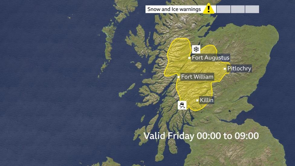
Snow warnings are currently in place for central and north-west Scotland, where 2 to 5cm of snow is anticipated fairly widely, including at lower elevations. In some locations above approximately 350 metres, snowfall could reach around 10cm.
Wintry conditions are also possible over the hills of Northern Ireland, the English Lakes, and the Pennines.
Throughout the day, a mix of sunny spells and blustery showers is expected, with hail and thunder also possible. The turbulent atmosphere may produce striking cloud formations and occasional rainbows.
It is likely to start frosty in northern areas, with daytime temperatures struggling to reach double figures except in the south-east. Although winds are not expected to be as strong as on Thursday, blustery conditions will enhance the cold feel, particularly around showers where winds will be squally.
The Met Office has issued a yellow warning for snow and ice across central and north-west Scotland, effective until 09:00 GMT.
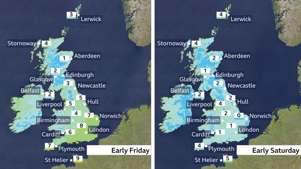
Overnight Temperature Forecast
Weekend Weather Outlook
The cold conditions are forecast to persist into the weekend, with a couple of frosty nights expected across Scotland and Northern Ireland. Daytime temperatures will remain slightly below average.
Saturday is expected to begin with frost and plenty of sunshine. Showers will develop and become more frequent by the afternoon, though not all areas will be affected. With lighter winds forecast, sunshine will feel pleasant.

On Sunday, showers are likely to be more numerous, accompanied by increased cloud cover and wind, which will reduce the likelihood of frost. By Sunday night, there is a renewed chance of showers turning wintry in northern regions.
The cold air mass is expected to linger until early next week, after which temperatures will gradually rise to slightly above the mid-March average.
For detailed hour-by-hour weather updates for your location, please check online or via the BBC Weather app.
Why Has the Weather Turned Colder?
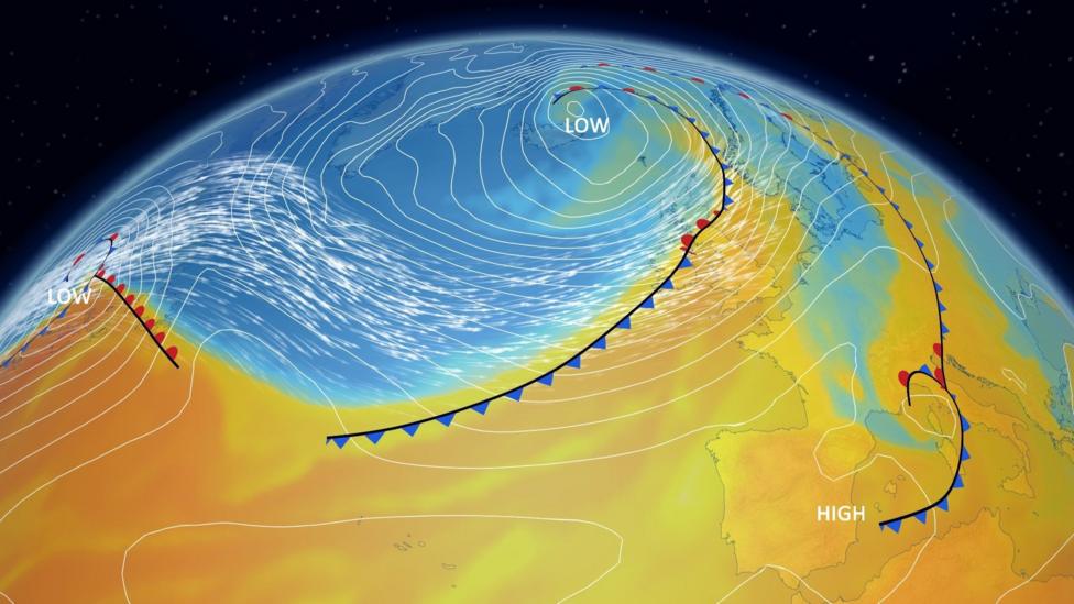
A strong jet stream has drawn cold Arctic air down over the UK.
The temperature across the UK is mainly influenced by the source of the air and wind direction.
The current cold spell can be traced back to the United States, where warm air from the Gulf of Mexico collided with cold Arctic air this week. This clash generated deadly storms, including tornadoes and record-breaking hail in Illinois.
This sharp temperature contrast strengthened the jet stream — strong winds high in the atmosphere that travel eastward over the North Atlantic.
With wind speeds exceeding 200mph, this powerful jet stream has contributed to the development of a deep low-pressure system near Iceland.
This system moved across the UK on Thursday, drawing down cold Arctic air behind it.
Additional Information
Wildflowers have blanketed Death Valley in the best display since 2016.


