

Temperatures Could Reach 30C in Bank Holiday Weekend Heatwave
Last year marked the hottest summer on record in the UK, with August experiencing one of four summer heatwaves.
Temperatures are forecast to rise as high as 30C in parts of the UK as a potential heatwave develops across the extended bank holiday weekend.
Heat health alerts have been issued by the UK Health Security Agency (UKHSA), in collaboration with the Met Office, covering much of the Midlands and south-east England. These alerts are valid from 09:00 on Friday 22 May until 17:00 on Wednesday 27 May.
The mercury is expected to increase daily for the remainder of the week before the warmest weather of the year so far settles in.
If temperatures reach 30C before Monday, it will be the earliest occurrence of such heat in the UK in over 70 years.
The warmest day of 2026 so far was on 8 April when temperatures in London reached an unseasonably high 26.6C.

Where Will There Be a Heatwave and How Long Will It Last?
The Met Office defines a heatwave in the UK as at least three consecutive days with daily maximum temperatures exceeding a county-specific threshold, indicating a sustained period of unusually hot weather.
The heatwave threshold temperature varies across the UK. For example, in Greater London it is 28C, whereas in Northern Ireland and Scotland it is 25C.
It is likely that some locations could meet the heatwave criteria during Friday, Saturday, and Sunday. Currently, areas such as London and the south Midlands are most likely to experience this.
With the unseasonable warmth expected to continue into Tuesday and beyond, additional parts of England and Wales may experience a heatwave after the bank holiday weekend.
Maximum temperatures forecast for Saturday to Monday indicate widespread warmth.
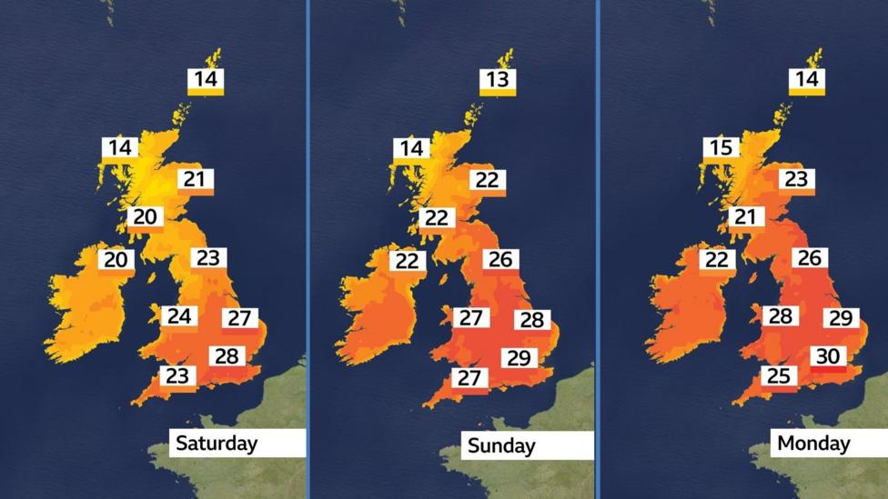
Even in areas where a heatwave is unlikely, temperatures are expected to remain warm over the long weekend, generally ranging between 20-26C.
As early as Friday afternoon, temperatures could reach up to 28C in south-east England.
This will represent the warmest weather of the year so far, surpassing the 26.6C (79.8F) recorded at Kew Gardens in April.
However, there remains uncertainty regarding the duration of this warm spell.
The most probable scenario is for heatwave conditions to persist until at least the middle of next week, with a transition to cooler and more unsettled weather expected from Thursday onward.
How Do Heat Health Alerts Work?
Heat health alerts are issued to inform the public and health services about periods of hot weather that may affect health, particularly for vulnerable groups.
These alerts differ from extreme heat warnings, which are issued when temperatures are expected to reach levels that pose a significant risk to health.
Guidance is available on ways to keep homes and individuals cool during hot weather, including six recommended methods to mitigate heat effects.
Why Is It Getting So Much Hotter?
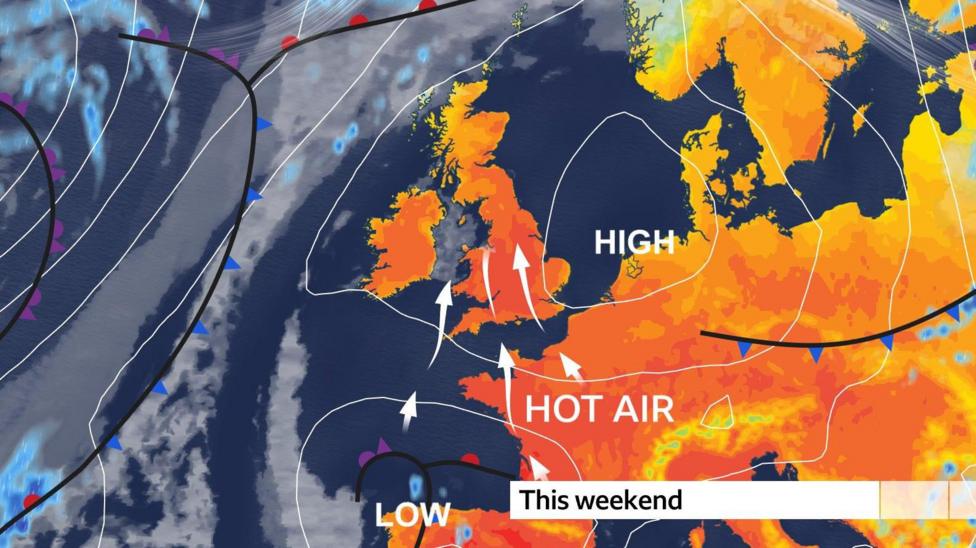
The primary reason for the warmer weather is a change in wind direction.
The jet stream is expected to shift north this weekend, allowing warmer southerly winds to bring hot air from southern Europe and North Africa.
This will create a stark contrast to last week when cold winds were blowing from the north.
It is uncommon for temperatures to reach up to 30C in the UK during May. The last occurrence was in 2012 in Scotland.
For England, this potential heatwave could bring the first May 30C since 2005. If 30C is reached before Monday, it will be the earliest 30C temperature recorded since 1952.
High pressure developing to the east will draw hotter air north across the UK.
Rain to Ease After Recent Downpours
Following recent downpours across many regions over the past week, rainfall is expected to ease.
This follows a period of exceptionally low spring rainfall for southern and eastern England up until early May. Some locations in south-east England have received only about a third of their expected spring rainfall so far.
Wednesday still carries a chance of scattered showers across most areas, but these will be less frequent than in recent days, with temperatures reaching around 21C.
Most parts of England and Wales are expected to remain dry on Thursday and Friday, while Scotland and Northern Ireland may experience occasional showers.
For the latest weather updates, refer to the BBC Weather app and the Weather for the Week Ahead.
- Warning of record global temperatures as chance of very strong El Niño grows
- UK should set maximum working temperature rules, advisers say
- How does sunscreen work, and how much do you need to use?


