

Spring Weather Brings Wide Swings Across the UK
Spring has commenced with notable fluctuations in weather patterns, and more variability is anticipated. Over a dynamic 48-hour period, the United Kingdom witnessed its warmest day of the year so far, a return of hill snow, as well as occurrences of Saharan dust and "blood rain."
Central and eastern England have recently experienced one of the driest weeks of the year, with rainfall amounts widely below 1mm, marking a welcome shift from the wetter conditions of previous months.
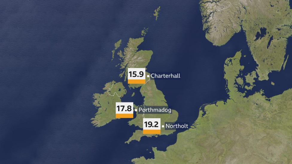
Temperatures have been above average nationwide, with England, Wales, and Scotland all recording their highest temperatures of the year to date.
This week saw Scotland, Wales and England all record their highest temperatures of the year so far
Despite the record warmth on Thursday, colder air briefly moved into northern parts of the UK on Friday, resulting in hill snow in areas of Scotland and northern England.
While the recent dry spells are notable, some regions have experienced even longer dry periods earlier in the year. For instance, parts of the Highlands enjoyed nearly two weeks of dry weather between late January and early February. Overall, the winter season for western Scotland and northwest England was considerably drier than average.
Saharan Dust Creates Sepia Skies and Blood Rain Across England
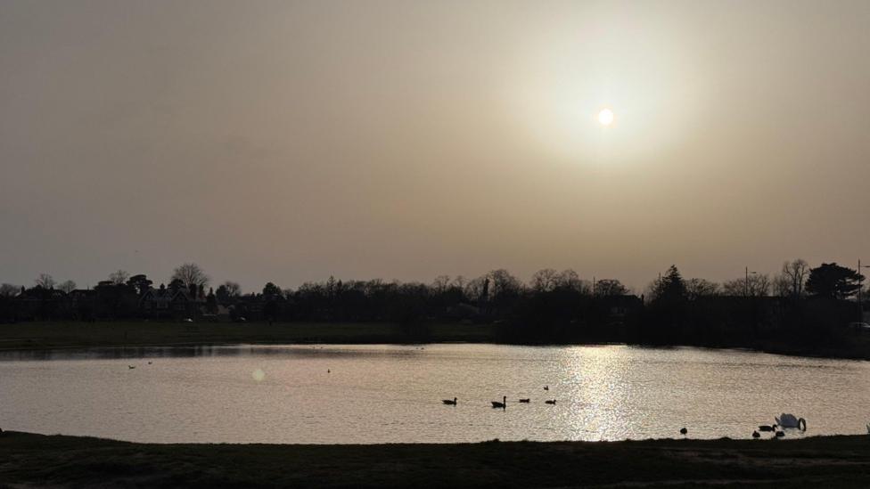
The mild weather was accompanied by southerly winds that transported a layer of Saharan dust from North Africa across the skies of England on Thursday and Friday. This phenomenon led to reduced air quality and a muted sunrise as the dust partially obscured sunlight.

A rather muted sunrise at Wimbledon Common as Saharan dust blocked some of the sun's light, the sky covered in sepia tones
Reports of "blood rain" emerged from parts of the Midlands, a condition where Saharan dust mixes with raindrops, leaving a reddish-brown residue on surfaces. This effect notably provided an explanation for visibly dirty cars across affected areas.
Photographs captured the eerie glow cast by the Saharan dust over parts of southern England, highlighting the unusual atmospheric conditions.
Weekend and Next Week's Weather Outlook
The upcoming weekend is expected to be mixed in terms of weather. Scotland and Northern Ireland will experience fine conditions with some sunshine on Saturday. After a cold and frosty start for some, afternoon sunshine should make it feel quite pleasant. Sunday will see increasing cloud cover, with the best sunshine likely in northern areas.
England and Wales are forecast to have predominantly cloudy conditions over the weekend, with potential patches of rain on Saturday and the likelihood of mist and fog on Sunday morning. However, cloud cover is expected to break up in southeast England by Sunday afternoon, allowing for spells of sunshine to develop.
Temperatures over the weekend will generally range between 11°C and 14°C, though in the sunshine of southeast England on Sunday, temperatures could reach as high as 18°C.
Looking ahead to next week, weather conditions are expected to become more unsettled, with periods of rain and occasional windy spells. The wettest and windiest weather will primarily affect western regions.
Temperatures will gradually decline during the week, raising the possibility of hill snow returning by the end of the week in Scotland, Northern Ireland, northern England, and potentially Wales.
Additional Information
- Temperatures exceeded 19°C on the warmest day of the year so far in parts of the UK.
- The UK winter did not set records despite experiencing floods and storms.


