

Discovery of Roman Fortlet in Bearsden
The remains of a small Roman fortification have been uncovered in the back gardens of three homes located in Bearsden, East Dunbartonshire. Archaeologists have identified the site as a fortlet, alongside probable surviving fragments of the Antonine Wall.
Nearly 2,000 years ago, the Antonine Wall marked the northernmost frontier of the Roman Empire. This defensive structure extended approximately 37 miles (60 km) from Bo'ness on the Firth of Forth to Old Kilpatrick on the River Clyde.
Significance and Function of the Fortlet
According to new research by Guard Archaeology, the fortlet would have provided soldiers with
"commanding views"over territories beyond Roman control. Fortlets typically served as bases and observation points for small patrols or detachments of troops.
Archaeological Excavations and Findings
The site in Bearsden was initially discovered in 2017 beneath the gardens of three adjacent properties during archaeological investigations conducted prior to a development project. An initial excavation revealed the stone foundations of a turf rampart.
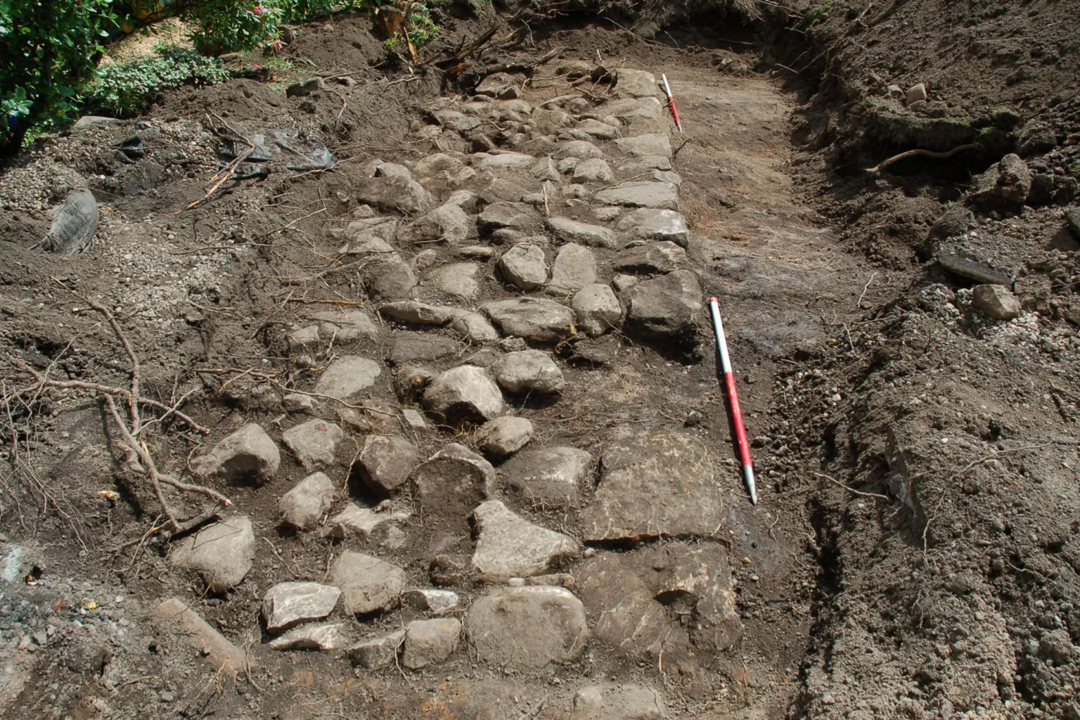
Following this, Historic Environment Scotland (HES), a public body, commissioned further excavation and research. During these investigations, a ditch containing peat deposits, wood, and vegetation was uncovered. A geophysical survey, which employs sensors to detect buried objects, subsequently identified stone structures believed to be surviving fragments of the Antonine Wall.
Expert Insights and Dating
Maureen Kilpatrick, the Guard archaeologist who led the work, explained the importance of the findings:
"What made these discoveries significant was that both the kerbed stone base and its parallel ditch lay perpendicular to the line of the Antonine Wall that crosses this part of Bearsden."

Wood samples taken from the bottom of the ditch were radiocarbon dated to AD 127–247, which corresponds to the period during and immediately following the use of the Antonine Wall. Additionally, two broken fragments of Roman pottery were found beneath the stone base.
Historical Context of the Antonine Wall
The Antonine Wall was constructed in the years following AD 142 by the Roman Army under the orders of Emperor Antoninus Pius. Guard Archaeology noted that the wall effectively divided Scotland, separating the conquered Britons in the south from the free Britons in the north.
In contrast to Hadrian's Wall, which was built primarily of stone, the Antonine Wall was constructed of turf laid upon a stone base. However, the Romans abandoned this northern frontier around the AD 160s, retreating back to Hadrian's Wall after little more than two decades of occupation.
Strategic Location and Landscape Analysis
Kilpatrick further elaborated on the fortlet's strategic position:
"This fortlet lay on an area of high ground right next to the Antonine Wall. It had commanding views over the landscape, particularly to the north, which was beyond Roman control."
She also noted the presence of a larger fort on lower ground nearby, suggesting that the fortlet was likely an
"integral part"of the wall's defensive system.
Specialist analyses of plant remains and fossil beetle evidence from the bottom of the ditch indicated that, at the time of the fort's construction, the surrounding landscape consisted of open pasture interspersed with areas of partially cleared woodland.


