

Dry Weather Persists Across UK This Weekend
Dry conditions are expected to continue across most parts of the UK throughout the weekend. Many areas will experience sunny spells, although some locations will encounter mist and fog patches, resulting in murky mornings for certain regions.
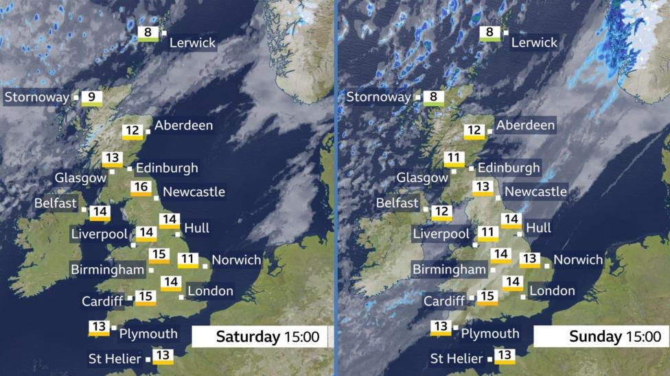
A band of cloud positioned over north-west Scotland on Saturday is forecast to move southwards on Sunday, potentially bringing a few spots of rain to affected areas.
On Friday, Fyvie Castle in Aberdeenshire recorded a maximum temperature of 20C (68F), marking Scotland's warmest day of the year so far. However, temperatures are anticipated to decline slightly over the weekend.
More significant weather changes are expected next week as the influence of high pressure begins to weaken.
Murky Mornings
Saturday and Sunday mornings will see some areas greeted by mist and fog. The fog is expected to be patchy, meaning some locations will be enveloped while others remain clear. Where fog does develop, it may be dense enough to reduce visibility on roads.
Fog forms when air temperature drops overnight. As the air cools, its capacity to hold water vapour diminishes. If the air is moist and the temperature falls sufficiently, excess moisture condenses into liquid water droplets, which manifest as fog.
During this period, just after the spring equinox, with increasing sunshine strength and longer days, fog typically dissipates relatively quickly. By late morning, most fog and mist should have cleared, allowing brighter conditions to prevail.
However, fog may persist longer along some Irish Sea coasts, potentially lingering into Saturday afternoon.
Spells of Spring Sunshine
Most regions will experience sunny intervals on Saturday, with the clearest skies likely across England and Wales. Northern Ireland, as well as southern and central Scotland, should also enjoy some decent sunshine.

Following a week that delivered the UK’s warmest weather of the year so far—with all four nations surpassing previous temperature highs—conditions will be somewhat cooler for many over the weekend.
Temperatures in most areas are expected to reach highs between 11-16C (52-61F), though it may feel chilly near some eastern coastal areas.
Northern Scotland will experience different conditions due to a weak weather front bringing increased cloud cover and a few spots of rain, accompanied by a moderate breeze.
Cloudier and slightly cooler conditions will sink southwards over the weekend.
Saturday night is forecast to be chilly again, with a possibility of frost in some locations, continuing a recent trend of cold nights.
Sunday will bring further sunny spells once morning mist and fog have cleared. However, cloud and patchy rain are expected to advance further south across Scotland and Northern Ireland, reaching England and Wales during the afternoon.
Turning Chilly Next Week
Looking beyond the weekend, the weather is set to remind us that it is still early spring. High pressure is expected to weaken, and colder conditions are likely to return.
After a predominantly dry Monday, a band of rain is forecast to move southeastwards on Tuesday. Following this, northerly winds will usher in a surge of cold air, with temperatures predicted to fall below seasonal averages in many areas.
While some sunshine will occur, showers are also expected, which could turn wintry over hills in northern parts of the UK.
For the latest updates on the evolving spring weather, the BBC Weather website and app provide current forecasts and information.
- Spring is the 'fastest-warming' season in the UK
- Tenerife hit by snow as Storm Therese brings wind and rain to Canary Islands


