

Weekend Cooldown to Follow Record Heat Across UK
Cooler air is expected to spread across the entire UK this weekend, bringing an end to a period of record-breaking heat. However, eastern and south-eastern England will experience a slower transition, remaining extremely hot throughout Saturday.
An amber warning for extreme heat, issued by the Met Office, remains in effect until 21:00 on Saturday for south-east England and East Anglia.
By Sunday, westerly winds and a weak cold front will usher in fresher air from the Atlantic, resulting in noticeably cooler conditions for most areas in the coming week.
Cooler Temperatures for Many, But Not All, on Saturday
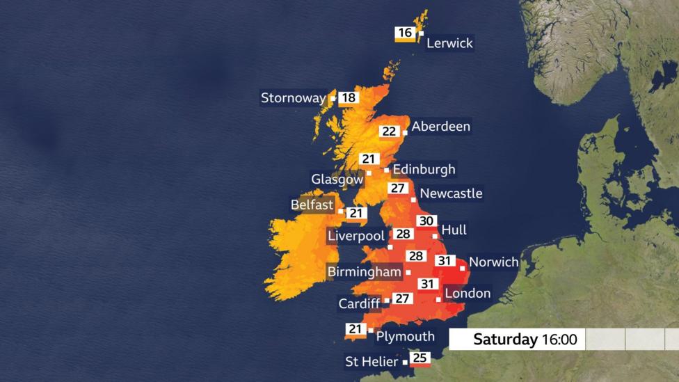
On Saturday, temperatures will generally fall back to the mid to high teens Celsius for many regions, although the south-east of England will still see temperatures around 17-20°C. Overnight thunderstorms have also been reported in some areas.
High pressure, which has been responsible for the recent sunshine and heat, is beginning to move eastward. Meanwhile, low pressure is centered to the north-west of the UK, bringing weather fronts from the Atlantic.
The wind direction will shift from southerly to westerly, facilitating the arrival of cooler air.
Scotland will experience a cloudy start but will see a mix of sunny spells and scattered showers developing throughout the day, with some heavy and locally thundery showers expected.
It will remain hot in eastern regions on Saturday, though temperatures will be cooler compared to earlier in the week.
Northern Ireland is forecast to have periods of showery rain interspersed with sunny spells.
A moderate to fresh south-westerly wind will prevail in northern and western parts of the UK. Temperatures across Scotland, Northern Ireland, western Wales, and the far north and south-west of England will peak in the low twenties Celsius.

Central, eastern, and south-east England will continue to experience hot conditions, with afternoon temperatures reaching the high twenties or low thirties Celsius. Winds in these areas will be lighter, accompanied by strong sunshine and a chance of isolated thunderstorms.
When Will the Heatwave End?
Sunday marks the conclusion of the current heatwave across the UK.
Weather fronts will move eastward overnight into Sunday, driven by south-westerly winds, bringing cloud cover and scattered showers nationwide. Some showers may be heavy, particularly in southern England.
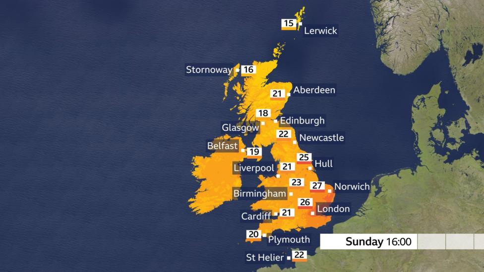
Sunshine is expected both ahead of and behind the front, which will usher in cooler air. Scotland and Northern Ireland will see temperatures in the mid to high teens Celsius, with eastern Scotland possibly reaching the low twenties.
Temperatures on Sunday will align more closely with seasonal averages but will remain warm in eastern regions.
England and Wales will experience temperatures in the low twenties Celsius across many areas. The extreme heat in eastern and south-eastern England will finally ease, with temperatures dropping to the mid-twenties.
Prospects for More Heatwaves This Summer
The UK has already experienced two heatwaves this year, both resulting in new national monthly temperature records.
With meteorological autumn not beginning until 1 September, there is still a significant portion of summer remaining.
Long-term forecasts for the next two months indicate that significant heat bursts are likely, with temperatures expected to remain above average.
According to the Met Office, a hotter summer is twice as likely as at the beginning of the century.
Additional Context
Heatwaves have also affected other parts of western Europe, including France and Spain, where record temperatures have been recorded.
This ongoing heatwave has drawn attention to the increasing frequency and intensity of extreme heat events in the region.


