

Ongoing Heatwave and Dry Conditions Across the UK
Heatwave conditions are expected to persist across many regions of the UK over the coming days, with some areas potentially experiencing nearly a month without measurable rainfall.
Large parts of England have recorded 0% of their typical July rainfall so far this month, with Wisley in Surrey having gone 26 consecutive days without any measurable rain. Rainfall levels in Wales and Northern Ireland are also significantly below average.
Currently, more than eight million households in England are subject to hosepipe bans. The continued dry weather increases the risk of wildfires, with active fires reported in locations including Greater Manchester and Conwy.
High pressure systems are expected to dominate the UK weather forecast for at least the next week, with temperatures reaching up to 33°C in southern England. This will result in very limited rainfall.
A Hot, Dry Summer So Far
High temperatures have been a prominent feature of this summer, breaking several records:
- New UK June temperature record: 37.7°C at Lingwood, Norfolk, surpassing the previous record of 35.6°C from 1976.
- New record for number of days reaching 35°C or above: six days this summer so far, exceeding the previous record of five days set in 1976.
- New record for number of days reaching 34°C or above: nine days this summer so far, surpassing the previous record of eight days set in 1976.
Additionally, this is the first year on record where temperatures of 35°C or above have been recorded in three different calendar months: May, June, and July.
Alongside the heat, the lack of rainfall is a significant aspect of this summer's weather.
Several locations have experienced no measurable rainfall for approximately three weeks or longer:
- Wisley (Surrey): 26 days without rain.
- Herstmonceux (East Sussex): 24 days without rain.
- Cardington (Bedfordshire), Wittering (Cambridgeshire), Odiham (Hampshire), Heathrow (London): 20 days without rain.
For context, Wisley typically receives 49.3mm (1.94 inches) of rain in July, while Odiham averages 50.8mm.
Provisional Met Office data indicates that during the first 11 days of July, most locations received less than 20% of their usual monthly rainfall, with some areas receiving none at all.
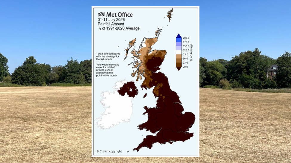
Most parts of Wales have recorded less than 10% of their average July rainfall, and in Northern Ireland, figures range from 1% to 20% of normal levels.
The notable exception is north-west Scotland, where most areas have received 40% or more of their typical monthly rainfall.
Aultbea (Highland) has already recorded 95% of its usual July rainfall, with over half the month still remaining.
By this point in July, most sites would have expected to have received approximately 35% of their total monthly rainfall.

Forecast Outlook
High pressure is expected to remain near the UK for the remainder of the week, maintaining dry conditions across most areas.
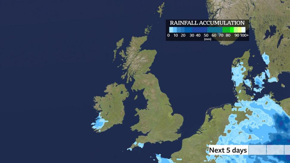
While a few showers and thunderstorms may occur, these will be confined to the far south of England and the Channel Islands. Even in these areas, some locations may remain dry between downpours.
Looking further ahead, some computer models suggest that high pressure could persist throughout the next week and possibly beyond.
Five-day rainfall accumulations across most of the UK are expected to be zero.
The risk of wildfires will continue, particularly where dry weather coincides with breezy conditions.
Natural England has issued warnings of a "very high" or "exceptional" fire risk across much of England and Wales over the coming days.
Active fires are currently burning in several locations, including Derbyshire, Greater Manchester, and Conwy.
While dry weather alone does not cause wildfires, ignition sources such as sparks from barbecues or discarded cigarettes can start fires. Dry conditions reduce moisture in vegetation, increasing its flammability and enabling fires to sp easily.
When Will the Heatwave End?
After a slightly cooler start to the week, temperatures are expected to rise again, reaching 32 to 33°C (90-91°F) in southern England by midweek.
Many areas across Scotland, Northern Ireland, Wales, and England will experience temperatures in the mid to high twenties Celsius.
Heatwave conditions are likely to continue for several more days in some regions, potentially lasting up to two weeks in certain locations.
Northerly winds may bring slightly cooler temperatures by the weekend, though temperatures are expected to remain above seasonal averages, with heatwave thresholds possibly still being met in southern areas.
For ongoing updates on temperature highs and rainfall chances, the BBC Weather app provides detailed forecasts.
Additional Information
For further context on this summer's weather patterns, see:
- Are we in for a summer of serial heatwaves?
- How climate change worsens heatwaves, droughts, wildfires and floods


