Shipping Through the Strait of Hormuz in March
Since the beginning of March, just under 100 ships have passed through the Strait of Hormuz, according to data analysed by BBC Verify, despite intermittent attacks on vessels in the area by Iranian forces.
While some energy supplies and everyday goods continue to move through one of the world's busiest shipping lanes, daily traffic has decreased by approximately 95% since the Iran war commenced on 28 February.
Prior to the conflict, around 138 ships transited the strait each day, according to the Joint Maritime Information Centre, transporting about one fifth of the global oil supply.
Shipping analysts Kpler provided data showing 99 vessels have passed through the narrow strait so far this month, averaging just 5 to 6 vessels daily.
BBC Verify examined the ships undertaking these journeys and the risks involved.
Analysis of Ship Origins and Routes
Our analysis indicates that approximately one third of these recent crossings were made by ships with connections to Iran.
This group includes 14 vessels sailing under Iran's flag, as well as others subject to sanctions due to suspected links to Tehran's oil trade.
Additionally, nine ships were owned by companies with addresses linked to China, while six listed India as their destination.
The analysis also reveals that several ships not linked to Iran have docked at Iranian ports, including vessels owned by Greek companies.
Some ships successfully crossing the strait appear to be taking longer routes than usual.
Tracking data for a Pakistan-flagged oil tanker indicates it sailed close to the Iranian coast during its passage through the strait on 15 March, rather than using the more common route through the middle.

Bradley Martin, senior researcher at the US defence think tank RAND Corporation, told BBC Verify the ship was likely
"responding to some set of directions from Iran".
He suggested the ship's path could indicate the presence of mines or an effort by Iranian officials to make the vessel easier to identify.
By compelling vessels to reroute, ships enter Iran's territorial waters and are subject to Tehran's maritime regulations, according to Michelle Wiese Bockmann from Windward Maritime Analytics.
"My takeaway is that Iran is closing and controlling the strait by the fear of attack and also the fear of mining.
That's why everyone is having to go around and hug its territorial coastline instead of going through that international navigation channel,"she told BBC Verify.
Michael Connell from the US-based Center for Naval Analyses concurs that ships are taking alternative routes.
"They probably have some agreement in place with Iranian authorities that if they stick to a defined lane they're safe."

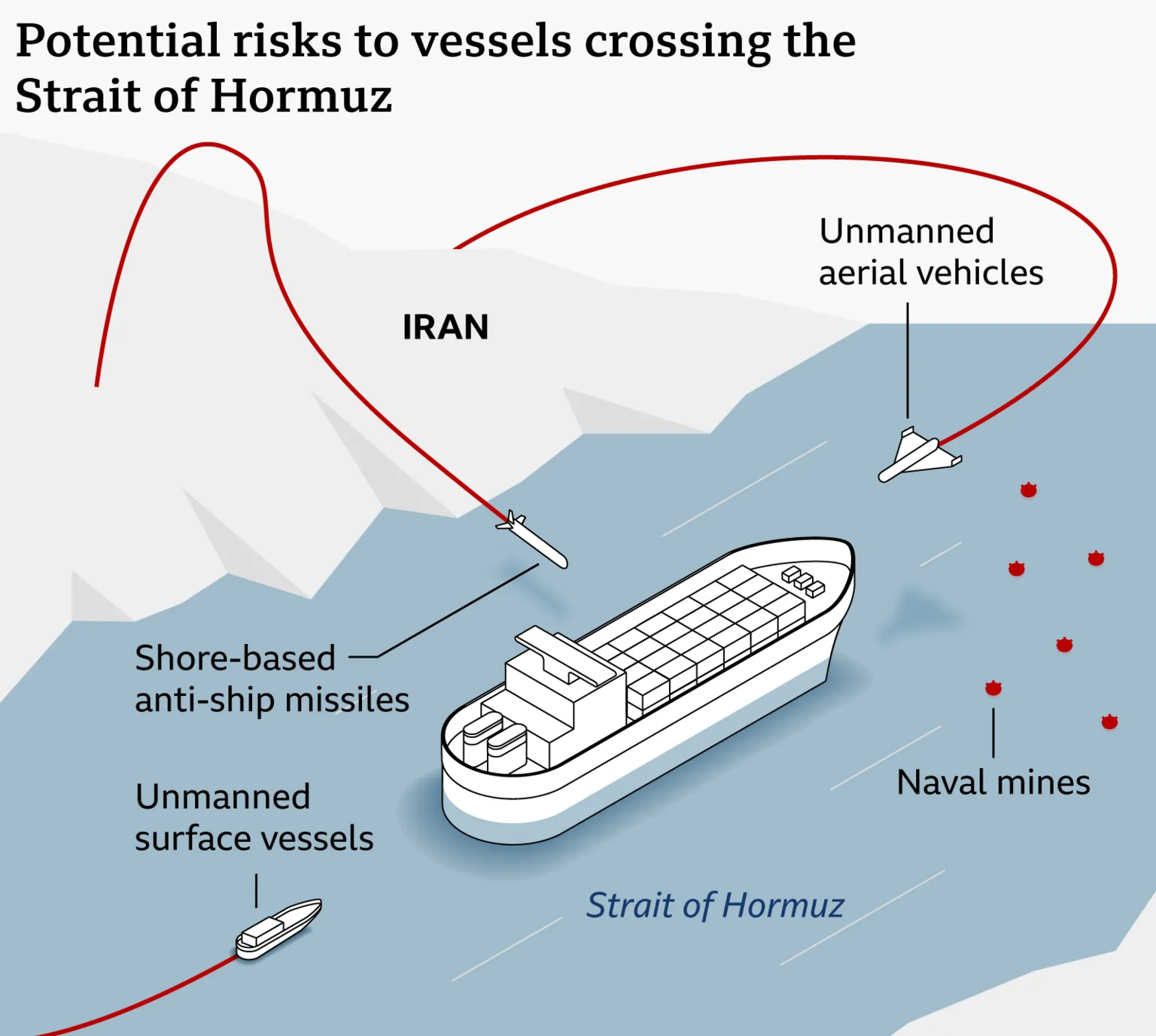
Four Threats to Shipping
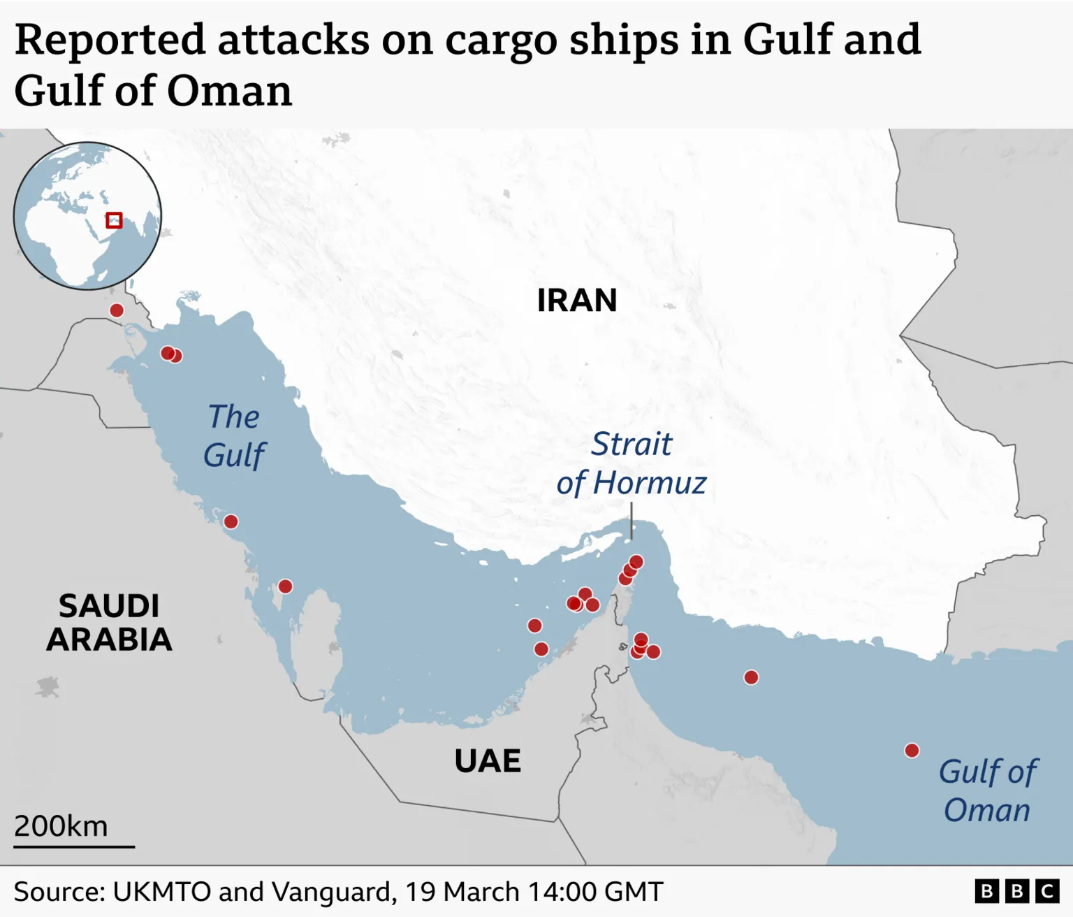
Since the conflict began, BBC Verify has confirmed 20 commercial vessels have been attacked off the Iranian coast, though not all incidents occurred directly in the vicinity of the Strait of Hormuz.
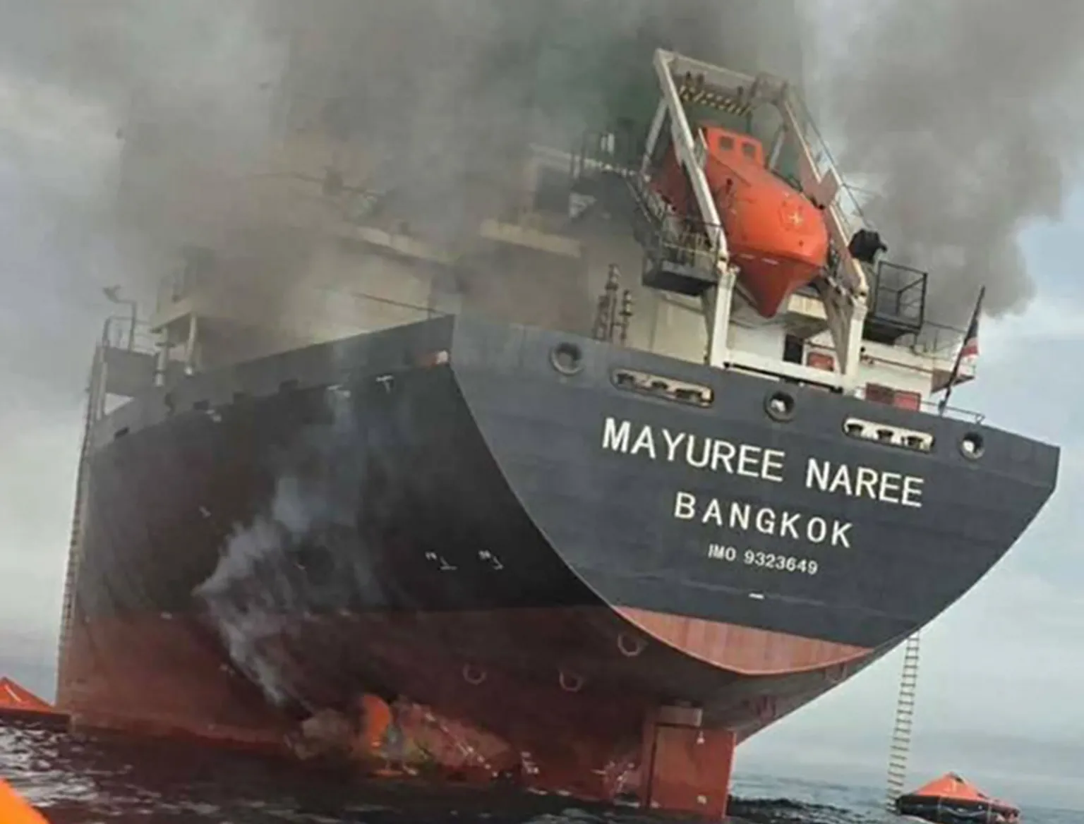
On 11 March, the Thai-flagged bulk carrier Mayuree Naree was struck by two projectiles while attempting to transit the strait.
Three of the 23 crew members remain missing, believed to have been trapped in the engine room at the time of the attack.
The ship's owners told BBC Verify the surviving crew were
"traumatised at sea when they were hit by two explosions".
Two other vessels—the Greek-owned Star Gwyneth and the US-owned MT Safesea Vishnu—were also attacked on the same day.
"Commercial shipping lanes cannot become battle zones,"MT Safesea Vishnu's owner told BBC Verify.
One person died in the attack while the ship was anchored off Iraq. All 28 crew members had to abandon ship by jumping into the water to escape the fire, according to Mr S V Anchan.
"These men and women are not soldiers… they are professionals who keep global trade moving."
The combination of threats—including drones, missiles, fast attack boats, and potentially mines—poses a significant challenge, said Arun Dawson from the King's College Freeman Air and Space Institute.
"A traditional minesweeper which is conducting slow, painstaking work is going to find it tricky to hunt for mines and deactivate them if they are also under air and surface attack,"he explained.
Iran can also exploit the geography of the strait to its advantage. The strait is narrow and shallow, with a mountainous coastline, enabling Iran to launch elevated attacks that give ships less time to respond.
Ships Concealing Their Movements
In an effort to evade detection, many ships appear to be deliberately switching off their Automatic Identification System (AIS) tracking devices.
"The vast majority of these [ships] have been crossing with their eyes off,"said Dimitris Ampatzidis from Kpler.
By disabling their trackers upon entering the Gulf of Oman, vessels disappear from tracking maps and then reappear hours or days later in different locations.
While this tactic helps ships conceal their positions, it also complicates efforts by firms like Kpler to monitor movements in the strait.
"Everything has been validated by our analysts through manual verification… and by using satellite imagery as well,"Ampatzidis told BBC Verify.
Additional reporting by Daniele Palumbo and Joshua Cheetham