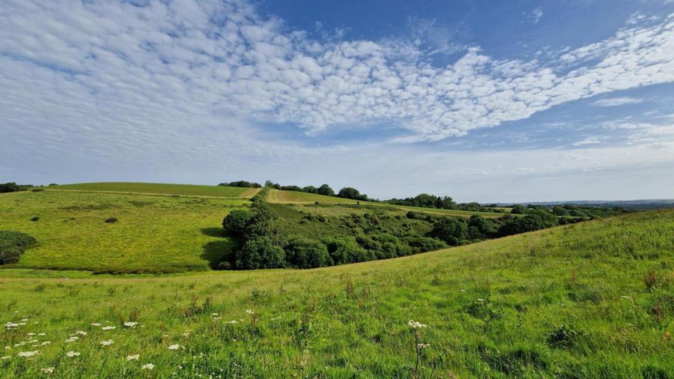
Summer warmth returns with drier weather expected
Summer warmth is anticipated to return intermittently this week, accompanied by drier conditions for most areas of the UK. Temperatures are forecast to reach up to 28C (82F) in certain locations.
Following a relatively cool week, all regions across the UK are expected to experience warmer conditions. While most areas will see drier weather, occasional spells of rain will still occur.
However, individuals affected by hay fever should be aware that pollen levels are likely to increase as temperatures rise following recent wet weather.
How warm will it get?
Temperatures across the UK are expected to be higher this week compared to last week. Daily temperatures may vary due to changes in wind direction and cloud cover but will generally be near or above the seasonal average. Nights and early morning commutes will also become warmer.
In western Scotland and Northern Ireland, temperatures are predicted to peak early in the week under gentle south-easterly winds, with highs around 19-21C (66-70F).
Elsewhere, with winds shifting between south and south-westerly directions, temperatures in the low to mid-20s Celsius are expected on some days.
Eastern parts of the UK are forecast to experience the highest temperatures later in the week.
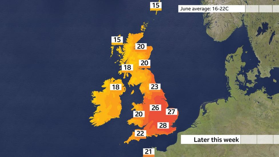
The main surge of heat is anticipated on Thursday and Friday. Heat building across parts of Europe is likely to influence the UK, particularly central and eastern England.
Forecasts suggest highs near 28C (82F), though sunshine duration and exact wind direction could cause temperatures to vary by a few degrees.
A shift to westerly winds over the weekend is expected to bring a temperature decrease. However, some computer models indicate a possible brief return of warmer conditions the following week.
Heat health alerts issued
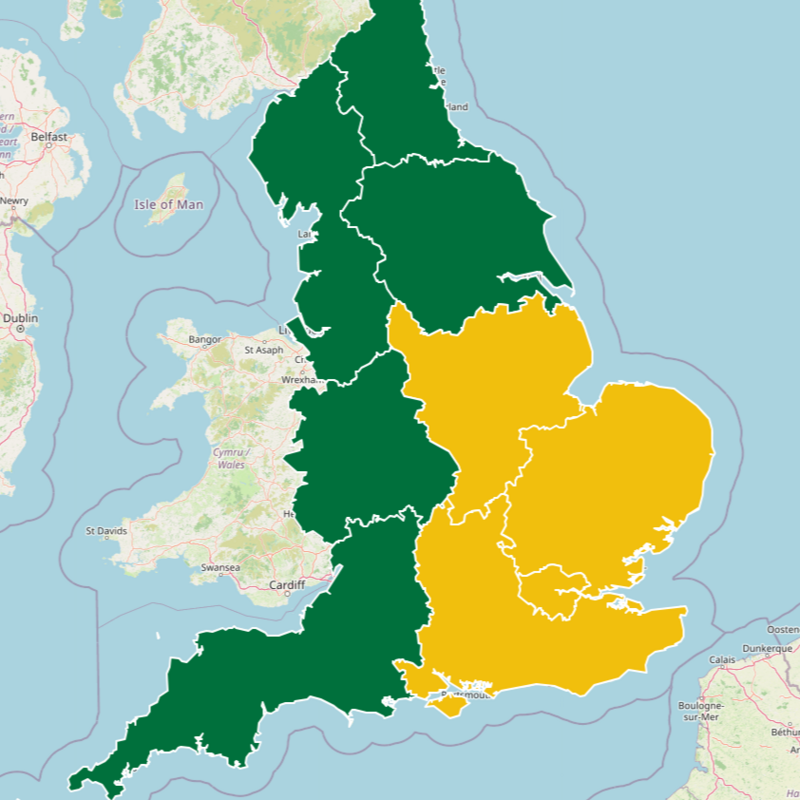
Heat health alerts have been issued for the East Midlands, East of England, London, and the south-east from Wednesday until Monday.
The UK Health Security Agency (UKHSA) has issued yellow heat health alerts effective from Wednesday 17 June until Monday 22 June for these regions.

These areas are likely to experience increased demand for health and social care services during this period.
The alerts aim to ensure that health services are prepared for the hotter weather and to mitigate the adverse health effects of prolonged heat.
According to the UKHSA, simple precautions can help individuals stay safe, such as maintaining hydration, avoiding sun exposure during peak heat hours, and keeping living spaces cool.
Weather battleground means rain still likely
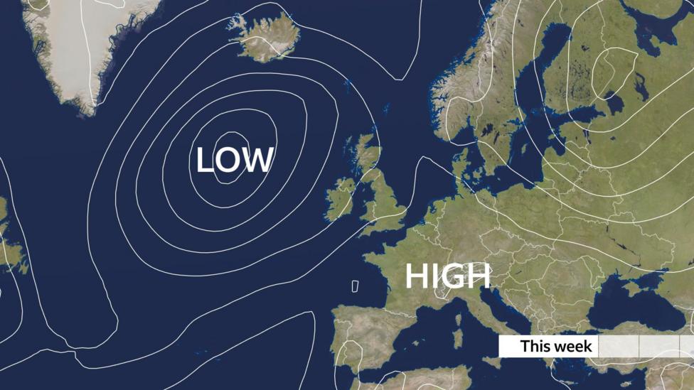
The UK is positioned between high pressure over continental Europe and low pressure in the North Atlantic, complicating the weather forecast for the week.
High pressure over mainland Europe is causing intense heat, with cities like Paris and Berlin expected to reach 35 or 36C (95 or 97F). Meanwhile, a cool and showery low-pressure system remains near the north-west of the UK.
These contrasting systems will influence UK weather, resulting in periods of hot sunshine interspersed with occasional rain showers.
Rainfall amounts will vary significantly; northern and western areas closer to the low-pressure system will likely receive more rain, whereas some southeastern locations may experience little to no precipitation.
Despite the chance of rain, overall rainfall is expected to be less than in recent weeks.
Midway through June, several sites in southern England, Cumbria, the Isle of Man, Dumfries and Galloway, and Northern Ireland have already recorded more rainfall than typical for the entire month.
Parts of East Anglia and southern England, including Norwich, Milton Keynes, and Bournemouth, have also experienced more rain so far this month than during the whole of June in previous years.
Pollen levels increasing
An increase in sunshine and warmth often brings certain drawbacks. Hay fever sufferers may have noticed an uptick in symptoms such as sneezing and itchy eyes as the grass pollen season approaches its peak.
Recent rainy days have suppressed some pollen levels, but these are expected to rise this week.
Warmer days typically lead to greater pollen release, and sunny, dry, and breezy conditions are particularly challenging for allergy sufferers.